The essential takeaway: decoding a ferry map reveals the strategic link between departure points and final island destinations. Selecting the correct arrival port—such as Bastia for the north or Ajaccio for the west—crucially minimizes driving time on winding mountain roads. This visual guide transforms complex logistics into a seamless travel itinerary.
Do you feel lost trying to identify the most efficient maritime route to the Island of Beauty among the myriad of confusing schedules and scattered departure points? A detailed corsican ferry map acts as the primary navigation tool you need to instantly visualize the dense network connecting mainland France, Italy, and Sardinia to your specific holiday destination. We break down exactly how to interpret these visual guides to help you select the strategic port that saves hours of driving, ensuring you avoid common logistical errors for a flawless Mediterranean getaway.
- Decoding the Corsican Ferry Map: What You’re Actually Looking At
- The Main Ferry Corridors: France, Italy, and Sardinia
- Choosing your port: more than just a dot on the map
Decoding the Corsican Ferry Map: What You’re Actually Looking At

The Key Elements of Any Good Ferry Map
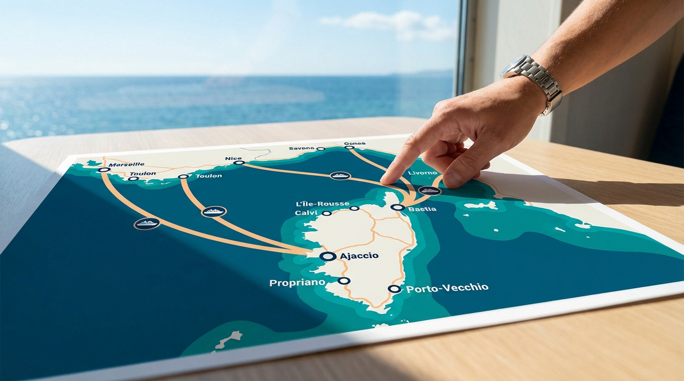
A Corsican ferry map isn’t your standard road atlas. It’s actually a simplified schematic designed for logic, not geography. Its sole purpose is highlighting maritime connections rather than showing the exact physical terrain.
You will see specific visual markers everywhere. Dots clearly mark departure ports like Marseille or Genoa and the arrival ports in Corsica. Thick lines connecting them represent the direct ferry routes.
Notice the distinct colors or logos on those lines? They correspond directly to different shipping companies. This visual trick helps you instantly identify who operates which specific route without any confusion.
Visualizing the Main Operators and Their Networks
Big names dominate this visual space immediately. You’ll see Corsica Ferries, Moby Lines, and Corsica Linea claiming their territory. Each operator sticks to its own specific network of predilection.
The map reveals these distinct territories clearly. For instance, Corsica Linea heavily controls the lines starting from Marseille. Meanwhile, other competitors focus their energy on the various Italian connections.
Think of this map as a strategic planning tool. It lets you see at a glance which companies offer the most options. You can then decide based on your specific departure point immediately.
The Main Ferry Corridors: France, Italy, and Sardinia
Connections From Mainland France
Marseille stands as the primary gateway from France continentale for most travelers. It is the historic, high-density artery feeding traffic directly to the island.
These crossings are marathons, typically consuming the entire night to cross the sea. It is a practical hack to arrive early morning, fully rested and ready on site. The map displays straight lines targeting the largest Corsican ports exclusively.
A standard nautical chart highlights four primary ports receiving daily or weekly traffic from Marseille:
- Ajaccio
- Bastia
- Île-Rousse
- Propriano
The Shorter Hops From Italy and Sardinia
Shift your gaze to the east. Routes launching from Italie and Sardaigne are drastically shorter on the map. This represents a different travel philosophy, faster and usually operated during the day.
Check The ferry connections from Sardinia to see the distinct difference. The famous run between Santa Teresa Gallura and Bonifacio is a mere hop. It is undeniably the network’s shortest span.
Here is a breakdown of how these distinct corridors compare on the map:
| Origin | Key Departure Ports | Typical Crossing Vibe |
|---|---|---|
| France | Marseille, Toulon | Longer, often overnight |
| Italy | Livorno, Savona | Medium-haul, day & night options |
| Sardinia | Santa Teresa Gallura | Very short, frequent day trips |
Choosing your port: more than just a dot on the map
Matching your corsican port to your destination
Your arrival port isn’t just a minor detail. Corsica is a rugged, mountainous island where internal travel takes ages. Picking the right entry point saves you precious hours of driving.
The logic here is actually quite simple: match north, south, east, or west. Your final holiday destination on the island must dictate your specific arrival port. Always map out your itinerary before you even look at the ferry schedules.
Here is how the geography usually breaks down for travelers:
- Bastia for Cap Corse and the northeast.
- Ajaccio for the west coast and central mountains.
- Porto-Vecchio or Propriano for the famous southern beaches.
- Île-Rousse for the Balagne region.
Foot passenger vs. vehicle: what the map doesn’t tell you
The map shows the exact same route line whether you are on foot or driving. Yet, the actual logistics are completely different. It is a major blind spot in planning.
As a foot passenger, you are totally dependent on public transport upon arrival. A well-connected port like Ajaccio or Bastia is therefore a smart, necessary choice. With a vehicle, however, almost any port becomes a viable entry point.
You need to check understanding the cost of bringing your car before booking. Obviously, traveling with a car has massive implications for your preparation and your total budget.
Mastering the Corsican ferry map transforms a simple crossing into a strategic advantage. By matching your arrival port to your final destination, you avoid long drives and maximize your time on the island. Use these visual insights to book the perfect route and start your Mediterranean adventure effortlessly.
FAQ
Which ports are typically highlighted on a Corsican ferry map?
On any standard ferry map, Bastia and Ajaccio stand out as the primary hubs due to their high traffic volume. However, a detailed map will also display strategic entry points like Île-Rousse and Propriano, which are served regularly from Marseille by operators such as Corsica Linea, as well as Bonifacio in the south.
Do the lines on the map indicate the duration of the crossing?
Generally, the map is schematic and does not show exact times, but the visual distance is a good indicator of the journey type. Long lines stretching from Marseille imply overnight crossings on large vessels, whereas the very short connection shown between Santa Teresa Gallura (Sardinia) and Bonifacio represents a quick 50-minute daytime trip.
Can I identify specific ferry companies on the map?
Yes, comprehensive maps often use colour coding or logos to distinguish between operators. You will typically see the network of Corsica Linea dominating the routes originating from France, while Moby Lines is visually associated with the connections from Italian ports like Genoa and Livorno.
Why does the map include connections to Sardinia?
The map includes Sardinia because the two islands are geographically very close, creating a popular “island-hopping” route. The link between Bonifacio and the Sardinian port of Santa Teresa Gallura is a key maritime corridor, allowing travellers to easily combine both destinations in a single trip.